● Improved functionality and interaction
between mouse cursor and cloud when drawing and editing
polylines
● Selecting polyline from project panel
now highlights in scene as well
● Polyline selection now limits to those
that exist in the current scene
● Added prompt to view imported
polylines into existing scene when imported into a project
● Added the ability to control elevation
units of DEM/GeoTIFF if none are contained in the file
● Improved speed of inserting and
deleting objects in cloud
● Added informative prompt if user
attempts to create a new scene when one already exists
containing those same objects
● Improved color edge identification
which includes preset defaults for grass and pavement
● Added improved editing tools to trim
and adjust color edges
● Added informative message when
importing solids with errors
● Improved Autosave function including
matching CAD save time and ability to disable
● Added Undo function to Draw All
Parking Lines
● Improved Paint Line and Parking Stripe
detection
● Added recognition of existing Paint
Stripes and Parking Lines to avoid duplication
● Improved feature extraction for poles,
hydrants and trees including ability to draw perimeter base
● Color Polyline now works in all color
modes
● Added unit based defaults dimensions
and additional control over curb extraction
● Added Red warning labels for missing
items in the Project Tree
● Improved consistency of the ESC key
while in commands
● When performing Bare Earth to Regions,
the Regions tab is automatically displayed
● Profile extraction now uses a modeless
dialog box for more controlled viewing
● Improved cloud visibility with
Intensity Color by automatically setting Minimum and Maximum
range limits
● Added adjustment options for Parking
Lines and the ability to count and export Stall Numbers
● Added ability to extract Parking
Lines, Paint Stripes and Color Edges in other than direct color
mode
● Added more options for color selection
including sphere, window and perimeter
● Added Shift->right Click Menu Point
Filters when creating and editing polylines
● Added new Building Extraction feature
● Improved Bare Earth with more
automation and simplified user input
● Added prompts to view cloud when
modified with commands such as Clean or Bare Earth
● Added option to set CAD view to
approximate cloud view
● Added Station and Width control for
Polyline Cross Section view in Camera Tab
● Improved user interaction for Extract
Plane command
● Added angle parameter to rotate the
survey by grid points
● Added point preview for survey by
grid.

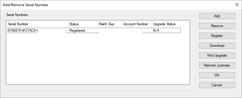
 (2)
(2)