|
 |
LandStar 8 Edition
Land Surveying and
Mapping Field Software for
Android
Easy to learn, easy to use,
powerful features, ready for North America,
the driving force behind Visual Surveying.
Works on most modern Android (Android
10 or higher) devices.
Easily transferred between field
controllers.
Compatible with all CHC and iGx RTK
receivers [ list
].
[
Evaluating LandStar8 ]
[ LandStar8
Pricing ]
[ Supported Equipment
]
[
What's New in LandStar8?
] [
LS8 User Manual ]
[ Data
Collector Comparisons ]
[ Price
Comparisons ] [
LS8 Videos ]
 |
8.2 Release
[ LandStar
8 is available as a no-charge update for current customers now!
] |
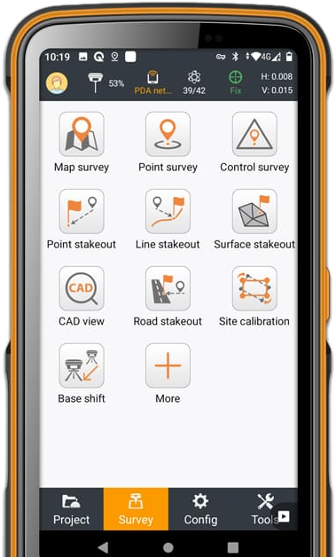
USER-FRIENDLY OPERATION
Easy to use and learn,
with powerful features
LandStar 8's simple and
intuitive layout, with large map windows and sharp graphics, makes
surveying and mapping easier for all users.
Only relevant information is
displayed, unused functions can be hidden to make the
application even more straightforward and simple
to operate.
Its modular design
provides flexibility, and its rich feature set makes LandStar 8 an
effective solution to meet the requirements of most applications.
Over 300,000 copies of
LandStar8 have been sold worldwide.
 |
 |
|
 |
Start Surveying
Quickly
Simplified project and
coordinated system management
When creating a
project, LandStar 8 makes it easy to copy coordinate settings,
control, and stake-out points from another handheld controller just
by scanning a QR code.
Projects can be
conveniently edited and sorted by history and properties, making
them easy to navigate. Custom coordinate systems, GEOID models, and
codification libraries, all dynamically updated via resource
packages.
LandStar 8 also features a site calibration wizard
specially designed to be uncomplicated for non-expert users.
|
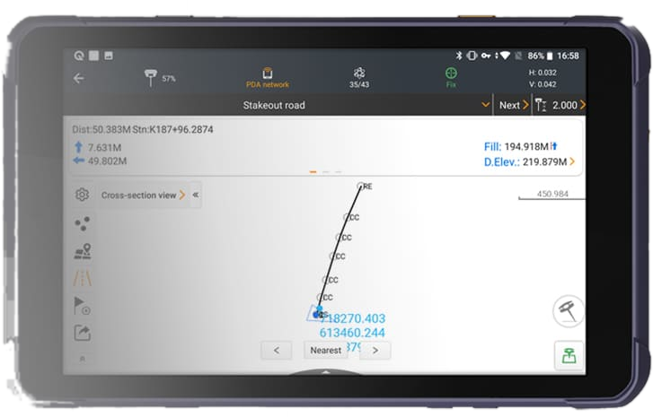
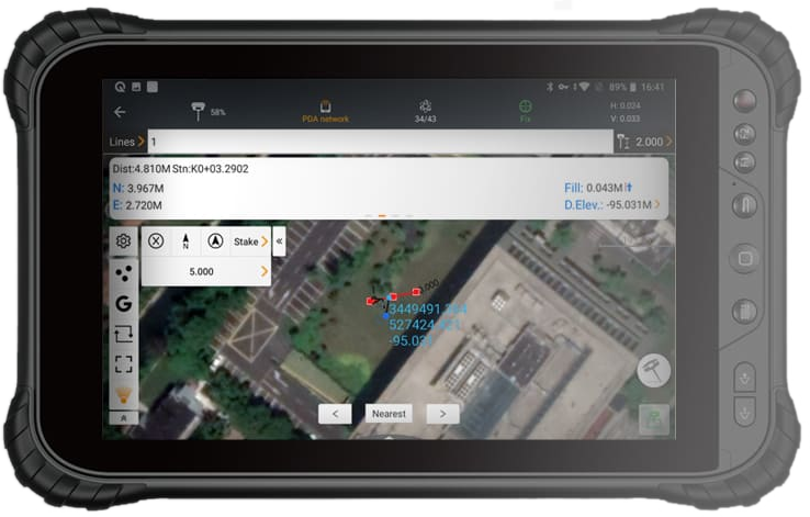
ADVANCED DISPLAY OF
BASE MAPS
CAD base map rendering in
seconds
LandStar
8's proprietary MetaCAD graphics engine opens DWG and DXF base maps
faster, with smoother rendering and an improved user experience.
DXF
files up to 200 MB can be opened on CHCNAV handheld controllers in
less than 10 seconds.
Smart
base map functions include "Quick Code" for one-click feature coding
to automatically create line features to increase project
productivity.
LandStar
8 supports the opening of external reference files, automatically
recognizes CAD length units, and allows editing of CAD base maps
directly in the field.
|
 |
Quick introduction to LandStar8:
|
Evaluating LandStar8
LandStar8 can be installed most
Android devices. Without activation it is full featured, only device
connection is limited. You can easily self service a 30-day demo
code to work with supported devices.
Check out this [
Step-by-Step Installation Guide
] for installation instructions.
Self-serviced 30-day demo activation is shown.
Consider watching the short installation [
videos ] to help
with your evaluation.
Purchasing LandStar8
LandStar8 is licensed by
purchasing a unique Registration Code (formally PreCode). A
Registration Code can only be deployed on a lifetime total of 5
devices; however, the code can be freely transferred between (back
and forth) these 5 devices an unlimited number of times.
LandStar8 GNSS includes all functionality Volume, Roading, and Visual Survey
functions.
LandStar8 TS includes drivers for manual and robotic
totalstations.
| Part Number |
Description |
Price |
| 4109 020 227 |
LandStar Data Collection Software (Android) GNSS License |
$ 790 |
| 4109 020 219 |
LandStar Data Collection Software (Android) TPS License |
$ 790 |
| 4109 020 220 |
LandStar Data Collection Software (Android) GNSS+TPS License |
$ 1,490 |
iGage has driven most of the North American version changes and
literally has written the book on LandStar8. We are confident of our
ability to support, drive new features, and obtain quick bug fixes.
The only way to obtain support
from iGage is to purchase LandStar8 and equipment from iGage.
LandStar8 supported equipment
|
LandStar supports a very large list of RTK Instruments, generic NMEA
receivers, the host Android Internal GPS receiver in the PDA and
includes a position Simulator.
This is partial list of devices:
CHC M5, X900+, X91+,
X6, iBase, E90, E91, M6, i50, i73+, i73, i70, i83, i80, i89,
i90, i93
JY i80, Z3, X91+
Champion Pro
Prince iBase, i90VR,
i90, i80, i70T, i80Air, i80Pro, i50, i30, i30 IMU Tx, X91
ELMIZ elNav, M3,
i70, i70Pro
Horizon Kronos C3
ComNav G9GNSS,
G7GNSS
TopoMap T10, T20,
T20 plus
iGage iG3S, iG4,
iG5, iG8, iG8a, iG9, iG9a
eGPS M5, eGPSM6,
eGPSM7, eGPS20T, eGPS20TL
Datronix D1, D20
GeoGenie NX, PRO
NMEA support works with most receivers. Best NMEA operation requires
GGA, GST, GSV, GSA at any interval. Performance will improve with
GGA at 1 HZ or faster.
What's new in the LandStar8
Edition?
|
This is a partial list: [
Version Information ].
 |
Visual Survey Data Collectors
|
|
|
Checkout the Android [ Data
Collectors for Visual Survey ] page for detailed data collector
comparisons.
We think the best tablet is the [
Tripltek 9 Pro ] and offer them bundled with LandStar.
|
|
|
|
We believe that
LandStar8 is a great field application, regardless of price. It
stands against all other field software on a feature bases.
However,
it may be interesting to compare deployed and maintenance costs for GNSS capability:
| |
GNSS
Base Price |
Annual Subscription |
Volume |
GIS |
Roading |
|
LandStar 8 |
$790 |
$0 |
included |
included |
included |
|
SPC |
$1,950 |
$395
/major update |
|
|
$750 |
|
GXP |
$1,280 |
$330/year |
$475 |
$85 |
$475 |
|
FGA |
$2,200 |
$300/year |
|
|
|
|
FGL |
$3,260 |
$150/year |
|
|
|
|
TA |
$1,025/year |
|
|
|
$615/year |
|
TM |
$2,175/year |
$395/year |
|
|
$570 |
In
addition, LandStar 8 allows multiple installations. This means you can use a phone
for boundary survey and a full sized tablet for construction survey,
with the same license. This can providing considerable value and flexibility
at no additional cost. (The license can only be used on one
device at a time.)
|
LandStar8 email list
|
|

Join this Email List to receive tech-tips and notices of new
versions and enhancements. |
*
|