RS10 SLAM+GNSS+IMU
|
|
|
|
Efficient loop-free workflow
The integration of high-precision GNSS and
SLAM technologies eliminates the need for
traditional loop closure, simplifying the data
collection process for handheld scanners.
The transition between outdoor and indoor
environments is seamless with the RS10's ability
to use the same coordinate system without the
need for additional Ground Control Point georeferencing. |
|
|
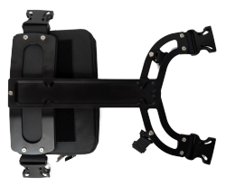
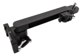
RTK, IMU and SLAM fusion for better mapping accuracy
|
| CHCNav's expertise in GNSS, IMU and
vision technology combines in the RS10.
Unlike other SLAM devices with quad helix or inexpensive
ground plane antennas slapped on a LiDAR sensor, the RS10 is
a top of line IMU tilt GNSS receiver combined with high
accuracy LiDAR. The RS10 features a 4th gen air dielectric antenna,
high-precision LiDAR and three synchronous HD cameras. |
|
|
| |
The RS10 isn't a mad-science project...
with cameras, IMU and GNSS bolted on a LIDAR handle as an
afterthought.
The RS10 is a tightly integrated, complete, engineered
solution.
CoPre2 the post-processing software is easy to use and
produces clean, industry standard .LAS point-cloud files. |
|
Note
For automatically georeferenced outdoor scans, the RS10 needs a
source of RTK corrections, or Static base data. This also works for scans that begin and
end outdoors where a GNSS fix is possible.
The RS10 does not have a UHF radio, so a cellular network is
needed for the tablet to connect with, corrections are passed from
the tablet to the RS10.
If a high-quality survey grade network is not available, but
cellular data coverage exists, it is possible to use a CHC Base
pushing corrections to the APIS service.
If cellular service is not available, a local base can record
static data which is combined with the scan data in CoPre2. The i83
and iBASE are both good choices for a local base because they
support static and APIS/RTK corrections:

 |
|
|
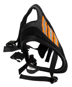
Pricing
Rental
kits include:
- RS10
- Backpack chest holder kit
- Desktop support pad
- LT800 tablet with SmartGo, clamp
- Thumb drive with the latest version of CoPre
- CoPre dongle for processing your scans
- 3 batteries, a 4-slot charger
- Hard case for the RS10
- Soft case for the backpack
Everything fits in a single 24" x 14" x 21" box that we ship to
you. Rentals can be daily, weekly or monthly. Rental charges start
the day after we ship and continue until the RS10 is returned. You are responsible for the equipment while
it is in your possession. We are responsible for routine
maintenance. You are responsible for damage.
RS10 Kit Rental Rates
|
| Monthly |
$ 4,400 |
| Weekly |
$ 1,470 |
| Daily |
$ 480 |
| |
| Lost CoPre2 Dongle |
$ 8,990 |
| |
| Training (at iGage) |
- variable - |
|
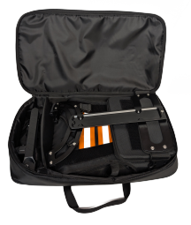
What's in the box?
The RS10 is a complete system and includes a tablet, case, chest
pack, acquisition software, perpetual post-processing software
(CoPre2), 3 1-hour batteries and a quad-charger. Everything needed
to acquire scans, process scans, evaluate check points and export
full resolution point clouds is included in one kit delivered in a
hard case with a high quality soft case for the backpack bracket
components:
|
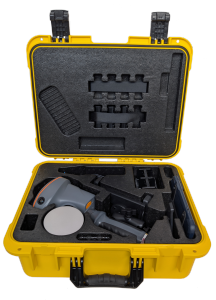
Carry Case Contains |
|
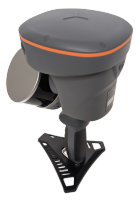
RS10 with desktop foot |
|
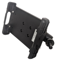
Tablet Bracket |
|
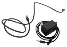
RS10 data cable,
Tablet cable and charger |
|
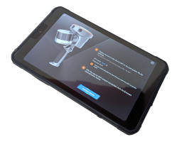
LT800 tablet with ScanGo |
|
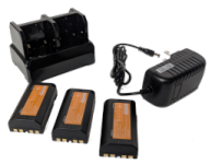
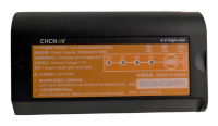
3 1-hour batteries with quad-charger |
|
More information
Checkout the [ operation
resources ] Videos
YouTube videos from the manufacturer:
|