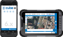
Features
Cube-a for GNSS RTK, GIS and Total Station surveys makes
work quick and easy, ensuring high productivity with
precision and efficiency.
GNSS
Cube-a is compatible with iG10 GNSS Receivers. It
supports Rover, Rover Stop&Go, Base and Static modes.
Various screens provide useful information on the status of
the GNSS receiver including the position and the signal
quality of the Atlas satellite.
SKY PLOT
Various screens provide useful information on the status
of GPS Satellites and Signals.
SURVEY
A simple and intuitive survey interface with numerous
indicators helps the surveyor to understand receiver
solutions. Indicators show various information like solution
status, position precision, battery levels, RTK correction
delays and more. Intuitive screens allow for an easy change
of settings, a view of the collected points, adding new CAD
elements and drawings or proceed surveying.
PHOTO & SKETCH
To improve and complete the survey and stakeout
functions, use the Photo & Sketch. This function can be used
while surveying or even on the already acquired points:
taking photos, adding notes, overlaying position with
annotation arrows or simple hand drawn sketches.
STAKEOUT
A compact interface groups all the stakeout commands on
one screen for easier field work. Stakeout screens are
enriched with both graphical and analytical indicators which
guide the surveyor to the target point. Even on small
displays, the information and commands are always smartly
arranged and readable, buttons are easily clickable and
rarely used buttons can be reduced to leave more map space.
INTEGRATED CAD
Cube-a includes a smart and easy to use CAD feature.
Designed for touch it allows easy points, line and polyline
creation with a smart pointer which can be moved using one
finger. Object-snaps like point, mid-point, endpoint,
intersection and others makes it possible to integrate the
survey with new elements directly in the field.
TOTAL STATION
Cube-a has fully supports mixed surveys. A Cube-a survey
supports GPS points and classical total station in the same
project. Total stations can be setup on previously collected
GPS points or on unknown positions initialized using
re-sectioning. The GPS reference system can be localized to
match an existing survey in local coordinates. Cube-a Total
Stations via Bluetooth.
GIS
GIS functionalities are integrated in the workflow of
standard GPS surveying. Thanks to Cube-a’s ability to
collect, not only single points but also to automatically
draw vectors passing through the collected points, GIS
surveying becomes fast and easy.
Feature code with attributes is automatic and
automatically follows the point or vector acquisition. Data
forms can be freely defined using the integrated Feature Set
designer or automatically created by Cube-a starting from a
sample DBF file.
Import and export of standard shapefiles ensures the
compatibility and interoperability of Cube-a with virtually
all other GIS software.
|