LandStar8 can be installed most
Android devices. Without activation it is full featured, only device
connection is limited. You can easily self service a 30-day demo
code to work with supported devices.
LandStar8 is licensed by
purchasing a unique Registration Code (formally PreCode). A
Registration Code can only be deployed on a lifetime total of 5
devices; however, the code can be freely transferred between (back
and forth) these 5 devices an unlimited number of times.
iGage has driven most of the North American version changes and
literally has written the book LandStar8. We are confident of our
ability to support, drive new features, and obtain quick bug fixes.
If you purchase LandStar8 or equipment from other sources, no
support will be available from iGage. The only way to obtain support
from iGage is to purchase from iGage.
LandStar supports a very large list of RTK Instruments, generic NMEA
receivers, the host Android Internal GPS receiver in the PDA and
includes a position Simulator.
CHC M5, X900+, X91+,
X6, iBase, E90, E91, M6, i50, i73+, i73, i70, i83, i80, i89,
i90, i93
JY i80, Z3, X91+
Champion Pro
Prince iBase, i90VR,
i90, i80, i70T, i80Air, i80Pro, i50, i30, i30 IMU Tx, X91
ELMIZ elNav, M3,
i70, i70Pro
Horizon Kronos C3
ComNav G9GNSS,
G7GNSS
TopoMap T10, T20,
T20 plus
iGage iG3S, iG4,
iG5, iG8, iG8a, iG9, iG9a
eGPS M5, eGPSM6,
eGPSM7, eGPS20T, eGPS20TL
Datronix D1, D20
GeoGenie NX, PRO
NMEA support works with most receivers. Best NMEA operation requires
GGA, GST, GSV, GSA at any interval. Performance will improve with
GGA at 1 HZ or faster.
In preparation for the release
of the i93 and i89 Visual Survey receivers into the North American
market, we have made extensive enhancements to LandStar8 2024
Edition.
Extensive prompt updates to 'American English'.
Quadrant bearings with 1234
shortcut entry, "342.354187641" => "S 42 35 41.87641 W"
Units:
length: meters, iFeet, USfeet with override entry for Chains,
Area: sq Meters, sq Miles, sq Feet, Acres, Hectares, sq Yards, mu
volume: cubic Meters, cubic feet, cubic yards, acre-feet
N, E or E, N coordinate order
Inline unit overrides for feet,
survey feet, chains links
Inline point inverse math for
distance and bearing:
"1001,1004" bearing from point 1001 to 1004
"1001,1005+90" bearing from point 1001 to 1004 plus 90 degrees
Inline calculator for distances
and bearings:
"1001,1004" the distance from point 1001 to 1004
"1001,1004/2" one-half the distance from point 1001 to 1004
Automatic description
builder/editor.
Option to store automatic
photographs stored when using Visual receivers for stored and
staked points.
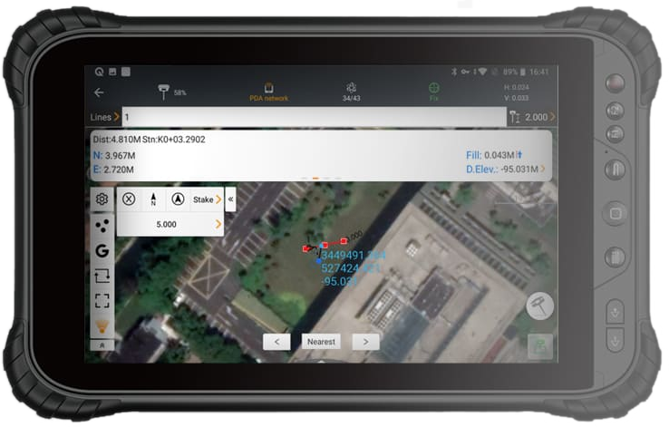
Offset point/line staking with
entered starting station: Landstar8 has extensive offset staking
methods for both Points and Lines. See the "Offset staking a
point" section of the User Manual for Point offsets. Line
stakeout includes Perpendicular, Skew ahead and Skew behind.
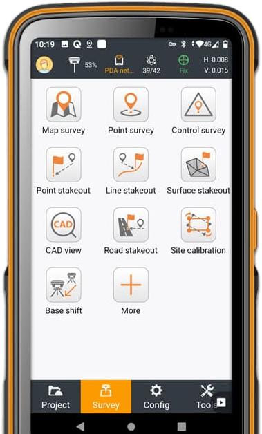
Roading routines are not optional,
they are included with all LandStar8 licenses.
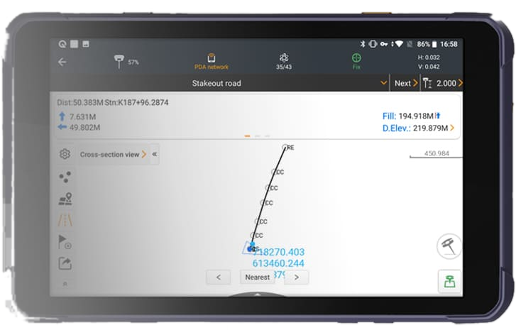
Road staking with alignments.
LandStar8 has an extensive cadre of alignment and profile
editors built in.
Station equations for road
staking.
Extensive offset point/line survey
for hidden point survey.
Continuous live project backups
while you work.
Deployment backups and restore
makes it easy to build a single file to move an entire
deployment including: Projects, Settings, Instrument Profiles,
Defaults, cached background tiles, background maps, photos,
Codes, Layer descriptions, custom projections.
Google Drive support, extensive
sharing options.
Cached background map tiles with
adjustable opacity. It is possible to download a background map,
then modify the opacity of the cached tiles to
Instrument profiles with one-click selection. Single button
switching from UHF to Network to Robotic operation.
Single-point localization with
grid, geodetic, aligned and manual basis of bearing, manual or
automatic NGS matching scale factors.
SPCS2022 Preliminary zones
included for experimental use
Verified surveys for automatic
collection of high-confidence measurements under canopy with
graphical reporting and residual display for mapping out ‘bad’
measurements. The GNSS measurement engine is factory initialized
between groups to insure that full new fixes are obtained.
Additional measurement groups can be collected with long
intervals between measurements.
Automatic Control point survey for
high-confidence measurements in wide-open canopy. Similar to the
Verified survey, however CPS runs from a start time to
completion with no breaks.
Alignment survey: prompting for
collection along an alignment (polyline) at even intervals and
specified offsets.
Auto Code increments for Z (zig-zag)
collection.
Foundation profile stakeout: build
offset profiles for pit excavation.
Sideslope stakeout for Area.
Subdivision by hinge or sliding
edge, specified by percentage or absolute
Import: .crd, .crdb, .loc, .xml, .kml,
.kmz, .shp, .dxf, .dwg, Leica, Trimble coordinate files.
Vector Export: starnet .dat and .gps,
.jxl. It is possible to directly write a .jxl file and import
points with vectors for import into TBC.
Extensive 2D and 3D Surface
building, viewing, editing, Stakeout with onboard volume
computations between surfaces.
Code file imports from other
tools, Code Grouping.
‘Code?Description’ The "?" can be
used to enter both the Code and Description in the Code entry
box.
Auto OK: enable to greatly reduce
the number of operations that require an OK to continue.
Transformation: translate, rotate,
scale or align by points.
Deed description entry with arcs,
lines and bearing + distance, cord bearings.
Smart Point averaging with graphs.
Previously stored measurements can be averaged with graphical
visualization of the spread, 1 and 2-sigma ellipses.
Americanized Inverse with Chains /
Links and Traverse modes.
Point to Line COGO: compute a the
offset of a point to a line, store/stake a point at the
intersecion point.
Lines and arcs annotated with live
Bearing / Distance dimensions in the CAD View.
Text notes in CAD.
Direct stakeout from CAD.
Direct stakeout from Map Survey
(in alpha)
Site calibration with point
imports from common tools.
Base shift for OPUS adjustments.
CORS shifts for VRS server
solution adjustments. Useful for making a network position
exactly match a specified value (dX, dY, dZ with no rotation or
scale.)
Support for forcing cellular data
connection when connected to a visual receiver by Wi-Fi while
using Visual receivers without onboard internet connections.
This allows older X91+ and iG8 receivers to be used as UHF bases
for new Visual receivers.
Support for all CHC, iGage
instruments including updated drivers for the X900+.
Robotic and manual Total Station
Support (release expected Q1 2024)
Detailed 300+ page, printed,
American English User Manual.
LandStar8 has no maintenance
charges.
One license can be shared (single
use) on 5 devices.
25-frame per second video
supported for visual instruments.
Unlike competing tools, LandStar8
can instantly activate visual functions.
Support for Android 13 on latest
generation Google Pixel devices.
Enhanced Visual survey status
balloons to not interfere with high rate point selections and
stores.